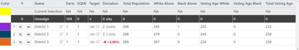
The current Ward Boundaries 1, 2, and 3 was created by Ordinance 1997-07 to defined equal representation of its elected official on the City Council. Each Ward is represented by Two Council Members. The Wards were not updated/changed after the 2000 and 2010 census. The 2020 census had enough population change in each ward to warrant changing the Ward Boundaries to have an equal number of residents per ward. The map below respresent the proposed Ward Boundaries with aproximately 295 plus or minus residents per Ward. The 2020 Census count for Cotter is 886 down from 970. The population base on the 1997 Ward Boundaries: Ward count (District is Ward) Ward 1 – 188 residents. Ward 2 – 210 residents. Ward 3 – 393 residents. Council in each Ward should have the equal number of residents per Ward. See below 2021 chart and maps of proposed Wards.